Interesting Tech Projects
Andy
Located in Tucson, Arizona, USA
Homepage: http://www.britishideas.com
Posts by Andy
Improved End Mill Rendering
Dec 17th
I played around with my Sketchup model a bit and vastly improved the flutes on the end mills. Here is a Kerkythea render

Google Sketchup and Kerkythea – A Perfect Combination
Dec 12th
Google Sketchup is pretty nice. I’ve tried 3D CAD programs in the past but never really invested the time to climb the steep (for me) learning curve. There was a bit of a learning curve with Sketchup, but once I got into the “right” way of thinking it became easy to use. Now I use Sketchup all the time, from drawing diagrams for my CNC hobby, to modeling home projects.
The one problem with Google Sketchup is, well, the output looks like a sketch. But now I’ve found a free renderer that not only has a plugin for Google Sketchup, but is just as easy to use as Sketchup. It’s called Kerkythea.
Install, run, and follow the quick start tutorial and you will be rendering your Sketchup models in less than a hour.
I recently decided to try and model and render some sprial up-cut and down-cut end mills in Sketchup. The results are below.

Spiral Up-cut End Mill

Set of Three End Mills on a Stainless Steel Surface
Ridgid R2400 Router
Dec 10th
I have made Christmas presents for this year, so now it’s time for some upgrades to my CNC machine. The first upgrade is to replace my poor Dremel with a small router.
Small palm routers or laminate routers are typically around 3lb in weight, which is small enough to fit on my hobby CNC machine. I liked the DeWalt laminate trimmer, but it doesn’t have variable speed built in. Next choice was the Bosch Colt, but I have heard some stories of how several hours of use can melt the plastic around the bearings, ruining them. My final selection was the Ridgid R2400 laminate router. Nothing but praise and easy to mount.
Note that the R2401 is quite different (and heavier) than the R2400. It seems that places like Home Depot and Lowes now stock the R2401 instead of the R2400.
A big reason for replacing the Dremel with a router is better performance under load and larger shank size. Larger bit = faster and deeper cutting. My Dremel has run for probably over 130 hours on my CNC machine and it’s showing the signs. It can still cut accurately but there is now a problem with the power, and it is starting to become a bit unreliable.
The first problem is how to mount the R2400 to my CNC machine. The solution I came up with is to press my Dremel into service one last time to cut some 1/4″ MDF. I will sandwich the parts together to create a holder that is 1″ thick with a back plate of 1/2″
The design was done in Google Sketchup:

I then rendered it in Kerkythea for fun:

Now to start cutting…
Map Scales and Printing with Mapnik
Sep 22nd
Mapnik is a nice open source library for generating maps. The typical data source is OpenStreetMap style data stored in a PostgreSQL/PostGIS database. This post examines how to understand and control the map scale and generate maps suitable for printing.
Map Scales
A map scale looks something like 1:1000. This means that for every 1 inch on the map there are 1000 inches in the real world. The units don’t matter, for example it also means that 1 meter on the map is 1000 meters in the real world. The value 1000 shown in this example is called the Scale Denominator.
Maps (in the context of this discussion) are generated using pixels. This is true even if printing because ultimately the printer has to print the pixels onto the paper (assuming a raster output). At low resolutions the pixels will be easily seen. Not so at high resolutions.
It is therefore useful for us to know the size of a pixel in meters. If we know this then we can work out the map scale and set the map scale. More >
OpenStreetMap and Beaches of the Rich and Famous
Sep 1st
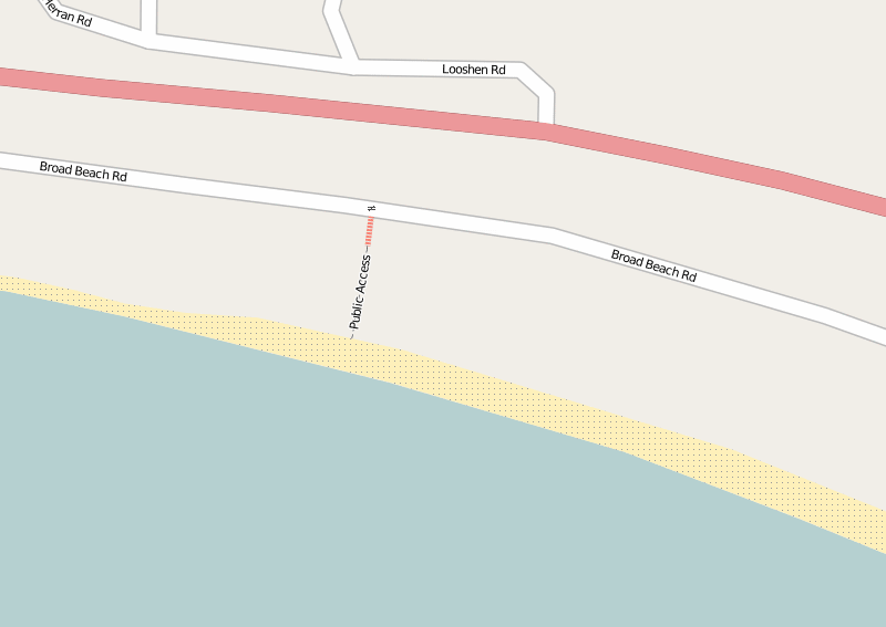
In Malibu, Calif. there have long been disputes between the rich and famous and the public over access to certain beaches. One of these is Trancas Beach (a.k.a. Broad Beach).
In the 100 or so houses along this beach are the homes of some of the most famous people in Hollywood. Under the California Constitution (Article X, Section 4) the public is allowed access to certain areas of beach, but the rich and famous apparently want to keep it all for themselves. They even bulldozed the sand to protect their homes but ruined the public section, before being made to undo the damage.
This beach has two public access walkways, but they can be hard to find. They are located between houses and are narrow. According to some reports the local residents try to obsure the locations and put up false signs to deter people.
Last weekend (August 2009) I went to the beach armed with my GPS unit. I recorded the western public access and I have now added it to OpenStreetMap. Within a few minutes it was rendered (showing the location, steps and the gate).
Now everyone will be able to put this onto their maps and GPS units, easily find this public access point and enjoy free parking and a quiet beach!
Twitter + Google Maps + Text Messaging Mashup
Aug 16th
I am planning a road trip and thought about using Twitter to send updates from the road. As my phone doesn’t have internet access and emailing using the Samsung interface is difficult, I would be restricted to text messaging. However I really wanted a way to post tweets with a link to a map showing my approximate location. Ideally it would allow vague descriptions such as “Euclid and Stone, Tucson” as well as latitude and longitude, e.g. “N 32. 16.123 W 110 18.654”.
Surprisingly a search turned up very few options. There is, however, a service that already does everything I want, and it’s called Geo.ly. So why not use it I hear you ask? Well there are two large problems. Firstly the twitter interface doesn’t seem to be working right now and appears to have reliability problems. Secondly about 20% of the time the service will give you a URL to a map that doesn’t work – all you see is a blank page.
After a bit more fruitless searching I sat down and wrote my own PHP code that pulls everything together. Here is how it works.
There is a free text messaging service called TextMarks that converts text messaging to/from HTTP requests and responses. All that’s needed to send and receive text messages is to write a PHP (or CGI) script and put it on a web server somewhere. I tried it and it really is a piece of cake.
Next was to convert the text description of a location into latitude and longitude. For this Google provides a free geocoding system, providing that the results are shown on a Google map. After a bit more work I had this working and it can accept a wide variety of input descriptions. For example the ones I listed above plus things like “Grand Canyon National Park”. Perfect.
The final piece of the puzzle was to automatically post the tweet with the location of the Google map using the Twitter API. I found that Twitter automatically shortens URLs in tweets using the bit.ly service.
So now I can send a text message with a rough description of my location, the location is converted to coordinates, a tweet is generated with a link to the map and a confirmation text message is sent back to my phone. This typically takes about 15 seconds. Nice!
Below is the PHP script. Use at your own risk. To install:
- Copy to somewhere on your webserver
- Go to TextMarks and create a new TextMark for your service
- Create a TextMarks account and edit the configuration. Disable messaging and any public options for your TextMark – after all you don’t want other people posting locations to your twitter account.
- Edit the script and enter your Twitter username and password. Also enter your Google Maps API key (which is free).
Note that there is no authentication used in the script. This is because the script is not linked to, uses an obscure name (not twitter.php, which is just an example name), and the TextMark is private. However, if desired, the TextMarks service can pass the phone number to the script allowing for only specific phones to use the system.
A public version would, of course, need more input checking, user authentication, etc.
<?php

// script to take a location description from a text message,

// generate a URL to a map and then tweet the URL

// the result is returned as a text message
// (C) Copyright Andrew Ayre, 2009

// andy at britishideas dot com
// call from TextMarks using something like:

// http://www.mydomain.com/twitter.php?args=\0
// This program is free software; you can redistribute it and/or

// modify it under the terms of the GNU General Public License

// as published by the Free Software Foundation; either version 2

// of the License, or (at your option) any later version.
// This program is distributed in the hope that it will be useful,

// but WITHOUT ANY WARRANTY; without even the implied warranty of

// MERCHANTABILITY or FITNESS FOR A PARTICULAR PURPOSE.  See the

// GNU General Public License for more details.

// You should have received a copy of the GNU General Public License

// along with this program; if not, write to the Free Software

// Foundation, Inc., 51 Franklin Street, Fifth Floor, Boston, MA  02110-1301, USA.

// See: http://www.gnu.org/licenses/gpl-2.0.html
// twitter username and password

$twitter_username = 'myusername';

$twitter_password = 'mypassword';

// API key for Google Maps

$google_mapsapikey = 'myapikey';
// max time to wait for tweet responses from twitter in seconds

$twitter_timeout = 30;

// max time to wait for Google geocoding service in seconds

$google_timeout = 30;
// get text message contents

$args = $_GET['args'];

// encode

$args = urlencode($args);
// geocode input

$req = curl_init("http://maps.google.com/maps/geo?q=$args&output=json&oe=utf8&sensor=false&key=$google_mapsapikey");

curl_setopt($req, CURLOPT_RETURNTRANSFER, true);

curl_setopt($req, CURLOPT_CONNECTTIMEOUT, $google_timeout);

$output = curl_exec($req);

curl_close($req);
// parse geocoding result

$result = json_decode($output, true);

if ($result == NULL) {

echo "Geocoding failed";

return;

}
// get address and coordinates

$address = $result['Placemark'][0]['address'];

$lon = $result['Placemark'][0]['Point']['coordinates'][0];

$lat = $result['Placemark'][0]['Point']['coordinates'][1];
// construct Google URL

$mapurl = urlencode("http://maps.google.com/maps?q=$lat+$lon&mrt=yp");
// send to twitter - based on

// http://morethanseven.net/2007/01/20/posting-to-twitter-using-php/

$tweet = "I am somewhere near $mapurl";

$req = curl_init('https://twitter.com/statuses/update.xml');

curl_setopt($req, CURLOPT_CONNECTTIMEOUT, $twitter_timeout);

curl_setopt($req, CURLOPT_RETURNTRANSFER, true);

curl_setopt($req, CURLOPT_POST, true);

curl_setopt($req, CURLOPT_POSTFIELDS, "status=$tweet");

curl_setopt($req, CURLOPT_USERPWD, "$twitter_username:$twitter_password");

$output = curl_exec($req);

curl_close($req);
// return result via text message

if (empty($output))

{

echo "Failed: $address, $lat, $lon";

} else {

echo "Tweeted: $address, $lat, $lon";

}

?>
Open Street Map Quick Start (JOSM)
Aug 6th
This is a description of how to quickly get going with OpenStreetMap. It is primarily aimed at people who don’t have a GPS unit or don’t want to use one. It’s also aimed at people who want to quickly add something to their local area. It is not a replacement for the OSM wiki.
Get JOSM
First download the current version of JOSM, which is a Java based editor. You will also need to install Java 1.5. You can also read more about JOSM here and here.
Start JOSM. On the command line this is something like:
java -jar -Xmx512M josm-latest.jar
There are some JOSM plugins that I think are essential, and here is how to add them:
- Start JOSM
- Go to Edit -> Preferences
- Click on the plugins tab (looks like a wall socket/outlet)
- Click on “Download List”
- Check/tick the following: utilsplugin, validator, waydownloader
- Click on “OK”
- Restart JOSM
Next you need to tell JOSM your OpenStreetMap username and password.
- Go to Edit ->Preferences
- Click on the connection settings tab (looks like a planet)
- Enter your email address and password
- Click on “OK”
Next install the WMS Plugin for JOSM that will allow you to view Yahoo satellite images.
Download a Section of the Map
Next you will want to download the part of the map that covers your local area.
- Click on the Download From OSM toolbar button
- Check/tick “Download as a new layer”
- Drag the map with the right mouse button, zoom with the mouse wheel or Ctrl + arrow keys
- Drag a box with the left mouse button to select an area to download. Keep it small for now.
- Click on “OK” and wait a bit. It could take a few minutes so don’t give up too quickly
You will now be looking at a black screen with lots of lines on it. Zoom in to a few streets using the magnifying glass tool on the toolbar.
Get the Satellite Images
The next step is to get the satellite images so we can see how the streets compare with the real world.
- Go to WMS -> Yahoo Sat (may have a slightly different name depending on the JOSM version)
At the top right under the Layers heading a new layer should appear called “Yahoo Sat” or something like that. Wait a bit and the images should start to appear.
Edit the Map
It’s now time to start editing. It should be clear if a street is not aligned with the Yahoo images. If it isn’t then you can click on the Select tool on the toolbar and start dragging the nodes (small yellow boxes). Position a road over where it is in the satellite image.
Upload!
Once you have fixed a few roads click on the Upload to OSM toolbar button.
- Enter a description for the change
- Click on “Upload Changes”
Once complete you can go to your OSM account page and view your edits. The URL is http://www.openstreetmap.org/user/myusername/edits. Replace “myusername” with your user name. You should see your first edit!
After waiting a few minutes your changes should start to appear on the map. Mapnik (the default renderer) renders the lower zoom levels more frequently, so you should see your changes appear in stages and only in some zoom levels. After a day or so all the lower zoom levels should show your changes.
Some Notes
The Yahoo satellite images are not always in the right place, but it seems from my experience they are pretty good. However this is something to keep in mind.
Along with fixing streets, it’s also possible to add in schools, malls, hospitals, businesses, rivers, streams, parks, etc. all by using the satellite images. There is plenty to do!
Mapping Summerhaven
Aug 1st
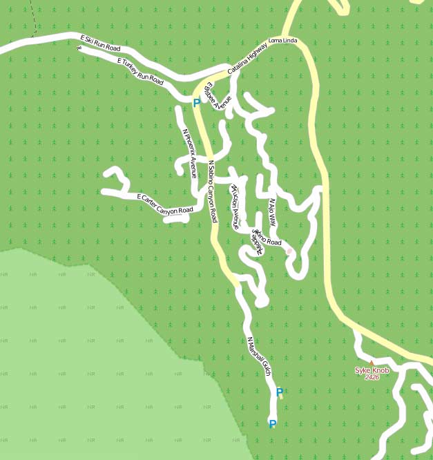
Previously I wrote on preparations to map Summerhaven for OpenStreetMap (OSM). This weekend we were able to get up there, drive around and take pictures. Here is the map as of yesterday:
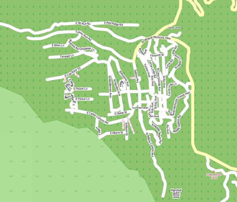
And here is the map today:
As you can see there are less roads. We found that many of the roads just don’t exist. Also after talking to some cabin owners we met, some roads have apparently been cut in two to build more cabins.
Comparing with the Google map we can see that we have missed a section of roads in the North East of Summerhaven, so we will need to go back for those sometime soon. Looking more closely at the Google map I can see many mistakes. Roads connecting when they don’t and the wrong names used.
Interestingly it seems Garmin have also used the incorrect TIGER data for their City Navigator NT. It contained a huge error which I corrected as soon as I saw it several weeks ago on the OSM map.
We marked on the map the locations of restrooms and parking areas, something which doesn’t appear on other maps.
Here is a screenshot showing our GPS trails overlaid on the TIGER data. As you can see the TIGER data is total nonsense.
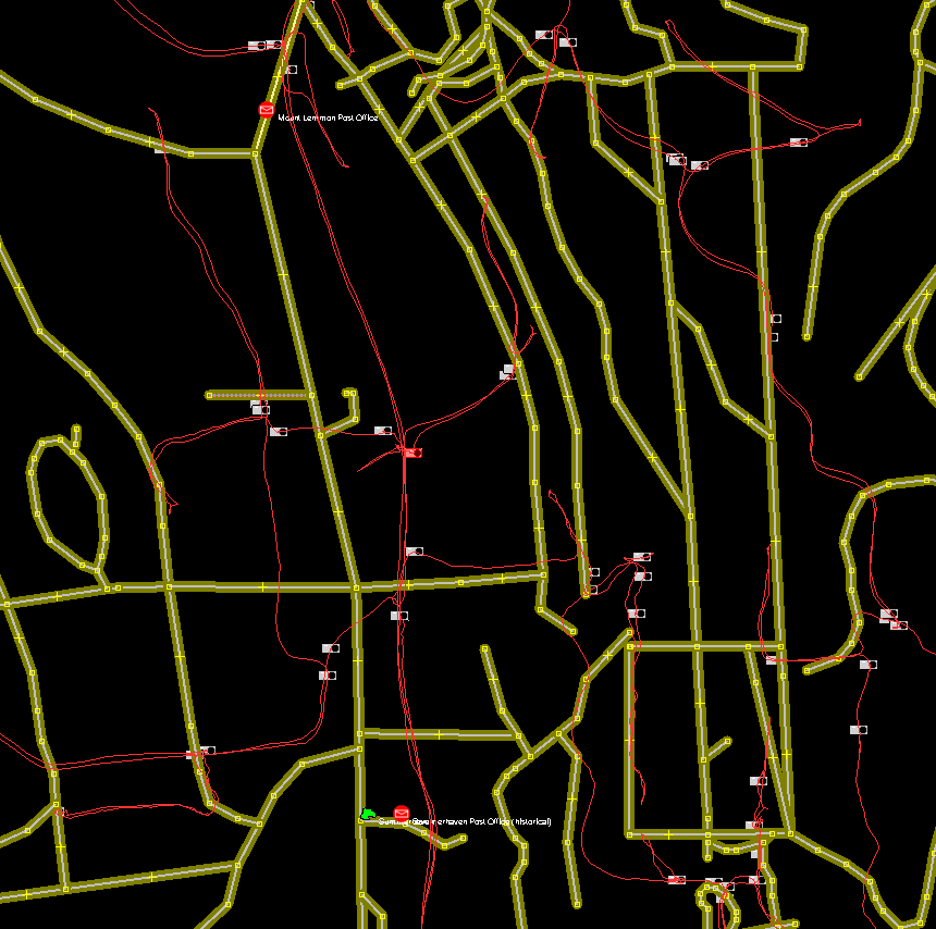
We have now compiled a list of about half a dozen specific items to look at when we next visit, however I can say that the OSM map must be the most accurate map of Summerhaven that is publically available, even if it isn’t completed yet.
OSM and Tucson
Jul 28th
I noticed that various cities and counties/states have pages in the OpenStreetMap (OSM) wiki, but Tucson didn’t. I’ve now fixed that with a page for Tucson that provides a list of projects with percentage of completion. I hope that will encourage people to contribute by giving them ideas of where to start.